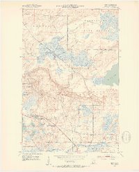
1951 Map of Britt
USGS Topo · Published 1953About this map
Kabetogama State Forest and the Superior National Forest dominate this landscape in St. Louis County, where the Iron Range Resources and Rehabilitation Commission collaborated with federal surveyors. The Duluth Winnipeg and Pacific railroad bisects the terrain, connecting small settlements like Britt and Forsman. Water defines the region's character, from the sprawling Big Rice Lake to smaller, distinct basins such as Jammer Lake, Wagon Wheel Lake, and Rat Lake. Local infrastructure of the early 1950s is evidenced by the Britt Post Office, a Town Hall, and Ranger Headquarters. The presence of the Arrowhead Lake State Game Refuge indicates the area's significance for wildlife management during this era. Genealogists can find the Sandy Cemetery near the eastern boundary, while surveyors noted several gravel pits and the winding course of the Rice River.
Find a feature on this map
28 named features on this map. Tap any name to fly to it.
Don’t see what you’re looking for? This feature index may not catch every label — zoom into the map to look around manually.
Map Details
Editions of this 1951 Britt Map
5 editions found
Other maps of this area

1950 · Mc Kinley
USGS Topo · 1:24,000

1950 · Biwabik NW
USGS Topo · 1:24,000

1951 · Mc Kinley
USGS Topo · 1:24,000

1951 · Biwabik NW
USGS Topo · 1:24,000

1951 · Virginia
USGS Topo · 1:24,000

1951 · Kinney
USGS Topo · 1:24,000

1951 · Britt
USGS Topo · 1:24,000

1952 · Idington
USGS Topo · 1:24,000

1954 · Hibbing
USGS Topo · 1:250,000

1956 · Lost Lake
USGS Topo · 1:24,000