1951 Map of Britt
USGS Topo · Published 1966About this map
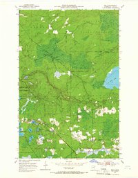
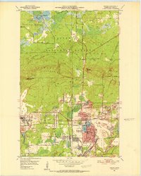
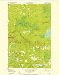
The Duluth Winnipeg and Pacific railroad cuts a diagonal line across this 1951 landscape, serving as a primary corridor through the Superior National Forest. Small concentrations of settlement are evident at Britt, where a Britt P O is located, and the northern siding of Forsman along the Rice River. This era shows a transition between active rail use and the established Railroad Grade paths that crisscross the wetlands and forests. Numerous small lakes, such as Jammer Lake and New Richmond Lake, are clustered near the Ranger Headquarters, while the expansive Big Rice Lake dominates the eastern edge of the survey. Local civic life is anchored by the Town Hall and the nearby Sandy Cem in the southeastern portion of the quadrangle.
Find a feature on this map
32 named features on this map. Tap any name to fly to it.
Don’t see what you’re looking for? This feature index may not catch every label — zoom into the map to look around manually.
Map Details
Editions of this 1951 Britt Map
5 editions found
Other maps of this area
1950 · Mc Kinley
USGS Topo · 1:24,000

1950 · Biwabik NW
USGS Topo · 1:24,000

1951 · Mc Kinley
USGS Topo · 1:24,000
1951 · Biwabik NW
USGS Topo · 1:24,000
1951 · Virginia
USGS Topo · 1:24,000
1951 · Kinney
USGS Topo · 1:24,000
1951 · Britt
USGS Topo · 1:24,000
1952 · Idington
USGS Topo · 1:24,000

1954 · Hibbing
USGS Topo · 1:250,000
1956 · Lost Lake
USGS Topo · 1:24,000