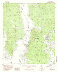
1984 Map of Broaddus
USGS Topo · Published 1984About this map
Broaddus serves as the primary settlement hub in this East Texas landscape, situated at the intersection of local routes just east of the expansive Sam Rayburn Reservoir. The terrain is defined by the dense woodlands of the Angelina National Forest, where a complex network of waterways like Indian Creek, Caney Creek, and Owl Creek drain toward the central reservoir basin. This 1984 provisional edition reflects the area's geography following the reservoir's creation, illustrating how the flooded valley of the Angelina River reshaped local boundaries and transport. The map details numerous smaller drainage systems, including Sandy Creek and Prairie Creek, which carve through the timbered uplands. Researchers can observe the close relationship between the forest management areas and the encroaching shoreline, providing a clear record of the region's late-20th-century hydrology and rural infrastructure.
Find a feature on this map
18 named features on this map. Tap any name to fly to it.
Don’t see what you’re looking for? This feature index may not catch every label — zoom into the map to look around manually.
Map Details
Editions of this 1984 Broaddus Map
This is the sole edition of this map. No revisions or reprints were ever made.
Other maps of this area

1931 · Zavalla
USGS Topo · 1:62,500

1953 · Palestine
USGS Topo · 1:250,000

1957 · Palestine
USGS Topo · 1:250,000

1958 · Zavalla
USGS Topo · 1:62,500

1958 · Broaddus
USGS Topo · 1:62,500

1958 · Mc Gee Bend
USGS Topo · 1:62,500

1958 · Bronson
USGS Topo · 1:62,500

1984 · Norwood
USGS Topo · 1:24,000
1984 · Veach
USGS Topo · 1:24,000
1984 · Etoile North
USGS Topo · 1:24,000