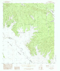
1984 Map of Veach
USGS Topo · Published 1984About this map
The Angelina National Forest dominates this mid-1980s landscape, where the dense timberlands of East Texas meet the expansive waters of the Sam Rayburn Reservoir. The map illustrates the complex interface between the reservoir and the original course of the Angelina River, which forms the boundary between San Augustine and Angelina counties. Smaller settlements like Veach and White City serve as anchor points in a region defined by its hydrology and forestry. Numerous tributaries, including Couchatana Creek and Ayish Bayou, thread through the wooded terrain toward the basin. The shoreline of the reservoir is particularly detailed, showing the formation of Coleman Bay and the low-lying Veach Basin, providing a clear record of the area's geography following the massive water management projects of the mid-20th century.
Find a feature on this map
21 named features on this map. Tap any name to fly to it.
Don’t see what you’re looking for? This feature index may not catch every label — zoom into the map to look around manually.
Map Details
Editions of this 1984 Veach Map
This is the sole edition of this map. No revisions or reprints were ever made.
Other maps of this area

1931 · Zavalla
USGS Topo · 1:62,500

1953 · Palestine
USGS Topo · 1:250,000

1957 · Palestine
USGS Topo · 1:250,000

1958 · Zavalla
USGS Topo · 1:62,500

1958 · Broaddus
USGS Topo · 1:62,500

1958 · Mc Gee Bend
USGS Topo · 1:62,500

1958 · Bronson
USGS Topo · 1:62,500
1984 · McGee Bend
USGS Topo · 1:24,000
1984 · Harvey Creek
USGS Topo · 1:24,000
1984 · Buck Bay
USGS Topo · 1:24,000