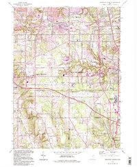
1994 Map of Broadview Heights
USGS Topo · Published 1997About this map
Broadview Heights and North Royalton anchor this late-twentieth-century study of the suburban landscape south of Cleveland. The map captures a moment of established civic infrastructure, evidenced by a high density of educational and religious institutions such as St Albert the Great Sch and St Basil Ch. The eastern edge is defined by the Cuyahoga Valley National Recreation Area, where the terrain drops toward Chippewa Creek, contrasting the residential grids found in Parma and Seven Hills. Large-scale public facilities, including the expansive Veterans Administration Hospital complex and the Mount Augustine Novitiate, mark the transition between developed heights and the valley floor. Transportation corridors like the Ohio Turnpike bisect the area, illustrating the post-war connectivity that spurred growth in communities like Brecksville and Richfield.
Find a feature on this map
52 named features on this map. Tap any name to fly to it.
Don’t see what you’re looking for? This feature index may not catch every label — zoom into the map to look around manually.
Map Details
Editions of this 1994 Broadview Heights Map
This is the sole edition of this map. No revisions or reprints were ever made.
Other maps of this area

1902 · Berea
USGS Topo · 1:62,500

1903 · Cleveland
USGS Topo · 1:62,500

1903 · Akron
USGS Topo · 1:62,500

1904 · Berea
USGS Topo · 1:62,500

1904 · Medina
USGS Topo · 1:62,500

1905 · Akron
USGS Topo · 1:62,500

1906 · Medina
USGS Topo · 1:62,500

1950 · Cleveland
USGS Topo · 1:250,000

1953 · Shaker Heights
USGS Topo · 1:24,000

1953 · Broadview Heights
USGS Topo · 1:24,000