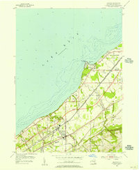
1954 Map of Brocton
USGS Topo · Published 1956About this map
The village of Brocton serves as a central hub on this mid-1950s survey of Chautauqua County’s Lake Erie shoreline. The landscape is defined by the intersection of legacy infrastructure and modern expansion, notably where the New York State Thruway was still listed as Under Construction parallel to the historic New York Chicago and St Louis RR. Local life is visible in the detailed mapping of the Drive-in Theater near Van Buren Bay and the Fredonia Airport, signaling the era's post-war mobility.
Find a feature on this map
57 named features on this map. Tap any name to fly to it.
Don’t see what you’re looking for? This feature index may not catch every label — zoom into the map to look around manually.
Map Details
Editions of this 1954 Brocton Map
2 editions found
Other maps of this area

1899 · Westfield
USGS Topo · 1:62,500

1900 · Dunkirk
USGS Topo · 1:62,500

1943 · Dunkirk
USGS Topo · 1:62,500
1954 · Dunkirk
USGS Topo · 1:24,000
1954 · Hartfield
USGS Topo · 1:24,000
1954 · Cassadaga
USGS Topo · 1:24,000
1954 · Westfield
USGS Topo · 1:24,000
1955 · North Of Dunkirk
USGS Topo · 1:24,000

1960 · Buffalo
USGS Topo · 1:250,000

1962 · Buffalo
USGS Topo · 1:250,000