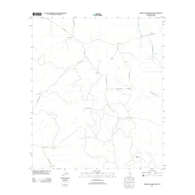
2012 Map of Brokeleg Mountain
USGS Topo · Published 2012About this map
Brokeleg Mountain rises above a landscape defined by expansive ranching operations in Sutton County, Texas. This 2012 survey reveals the network of private roads and county routes that connect isolated homesteads such as J Reilley Ranch, Schwiening Ranch, and Wyatt Ranch. The topography is shaped by intermittent drainages including Epps Cr and W Copperas Cr, with Pecan Springs serving as a notable water source in the northeast quadrant. The map provides a detailed view of the rural infrastructure at the start of the 2010s, showing a transition toward modern energy exploration indicated by the dense web of unnamed service roads weaving between established properties like the Luckie Ranch and Joy Ranch.
Find a feature on this map
30 named features on this map. Tap any name to fly to it.
Don’t see what you’re looking for? This feature index may not catch every label — zoom into the map to look around manually.
Map Details
Editions of this 2012 Brokeleg Mountain Map
This is the sole edition of this map. No revisions or reprints were ever made.
Other maps of this area

1893 · Rock Springs
USGS Topo · 1:125,000

1893 · Fort McKavett
USGS Topo · 1:125,000

1954 · Sonora
USGS Topo · 1:250,000

1958 · Sonora
USGS Topo · 1:250,000

1962 · Roosevelt
USGS Topo · 1:24,000

1963 · Buffalo Well
USGS Topo · 1:24,000

1963 · Live Oak Draw
USGS Topo · 1:24,000

1963 · McKegan Draw
USGS Topo · 1:24,000

1963 · Buffalo Well SE
USGS Topo · 1:24,000
1963 · Fort Terrett Ranch
USGS Topo · 1:24,000