
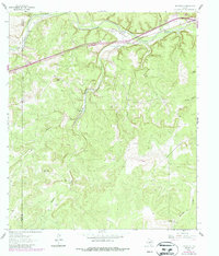
1962 Map of Roosevelt
USGS Topo · Published 1966About this map
Roosevelt sits at a strategic bend of the North Llano River in the early 1960s, serving as a focal point for the ranching culture of Kimble and Sutton counties. This period reveals a landscape dominated by large family landholdings and working ranch operations, with the Maynard Ranch and Holland Ranch anchoring the rugged terrain. The topography is defined by the prominent Patterson Ridge and distinctive high points like Cedar Knob and Joes Point.
Find a feature on this map
19 named features on this map. Tap any name to fly to it.
Don’t see what you’re looking for? This feature index may not catch every label — zoom into the map to look around manually.
Map Details
Editions of this 1962 Roosevelt Map
2 editions found
Other maps of this area

1893 · Rock Springs
USGS Topo · 1:125,000

1893 · Fort McKavett
USGS Topo · 1:125,000

1926 · Segovia 2-c
USGS Topo · 1:48,000

1932 · Junction
USGS Topo · 1:62,500

1954 · Llano
USGS Topo · 1:250,000

1954 · Sonora
USGS Topo · 1:250,000

1955 · Llano
USGS Topo · 1:250,000

1956 · Llano
USGS Topo · 1:250,000

1958 · Sonora
USGS Topo · 1:250,000

1962 · Hill Ranch
USGS Topo · 1:24,000