
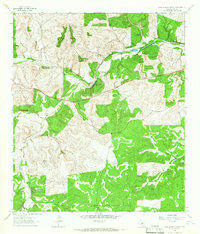
1963 Map of McKegan Draw
USGS Topo · Published 1966About this map
Llano River drainage systems define the landscape of this portion of the Texas Hill Country in the early 1960s. The terrain is deeply incised by a network of waterways including Copperas Creek, Middle Copperas Creek, and McKegan Draw, showing a rural landscape organized around large ranching estates. Named properties like Chadwick Ranch, Holland Ranch, and the P-6 Ranch reflect the long-standing livestock economy of the region.
Find a feature on this map
21 named features on this map. Tap any name to fly to it.
Don’t see what you’re looking for? This feature index may not catch every label — zoom into the map to look around manually.
Map Details
Editions of this 1963 McKegan Draw Map
This is the sole edition of this map. No revisions or reprints were ever made.
Other maps of this area

1893 · Rock Springs
USGS Topo · 1:125,000

1893 · Fort McKavett
USGS Topo · 1:125,000

1932 · Junction
USGS Topo · 1:62,500

1954 · Llano
USGS Topo · 1:250,000

1954 · Sonora
USGS Topo · 1:250,000

1955 · Llano
USGS Topo · 1:250,000

1956 · Llano
USGS Topo · 1:250,000

1958 · Sonora
USGS Topo · 1:250,000

1962 · Roosevelt
USGS Topo · 1:24,000
1963 · Fort Terrett Ranch
USGS Topo · 1:24,000