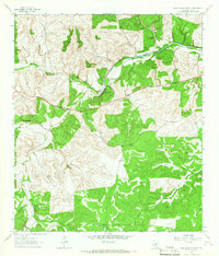
1963 Map of Fort Terrett Ranch
USGS Topo · Published 1966About this map
Fort Terrett Ranch (Historical Site) anchors this mid-century look at the Edwards Plateau, where the cattle-ranching economy of Sutton County is clearly defined by large family holdings. The drainage patterns of the North Llano River and the Dry Llano River dictate the placement of local infrastructure, from the Kingfisher Waterhole to the isolated Landing Strip. The landscape is characterized by prominent landmarks like Fort Terrett Peak, Chimney Bluff, and the Twin Buttes, which serve as natural signposts between the widely spaced headquarters of the Anderson Ranch, Burton Ranch, and Wade Ranch.
Find a feature on this map
25 named features on this map. Tap any name to fly to it.
Don’t see what you’re looking for? This feature index may not catch every label — zoom into the map to look around manually.
Map Details
Editions of this 1963 Fort Terrett Ranch Map
2 editions found
Other maps of this area

1893 · Rock Springs
USGS Topo · 1:125,000

1893 · Fort McKavett
USGS Topo · 1:125,000

1954 · Sonora
USGS Topo · 1:250,000

1958 · Sonora
USGS Topo · 1:250,000

1962 · Hill Ranch
USGS Topo · 1:24,000

1962 · Roosevelt
USGS Topo · 1:24,000

1962 · Stewart Ranch
USGS Topo · 1:24,000
1962 · Bundy Ranch
USGS Topo · 1:24,000

1963 · Live Oak Draw
USGS Topo · 1:24,000

1963 · McKegan Draw
USGS Topo · 1:24,000