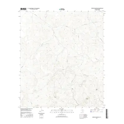
2016 Map of Brokeleg Mountain
USGS Topo · Published 2016About this map
Brokeleg Mountain dominates this portion of the Edwards Plateau, rising above a landscape defined by deep limestone drainages and intermittent water sources. The map details a network of private ranch roads, such as Pvt Rd 3501 and Pvt Rd 2273, which connect the isolated holdings of Sutton County. These routes weave through significant topographic depressions like Bell Hollow, Cat Hollow, and Spring Hollow, highlighting the importance of vertical relief in this semi-arid environment.
Find a feature on this map
22 named features on this map. Tap any name to fly to it.
Don’t see what you’re looking for? This feature index may not catch every label — zoom into the map to look around manually.
Map Details
Editions of this 2016 Brokeleg Mountain Map
This is the sole edition of this map. No revisions or reprints were ever made.
Other maps of this area

1893 · Rock Springs
USGS Topo · 1:125,000

1893 · Fort McKavett
USGS Topo · 1:125,000

1954 · Sonora
USGS Topo · 1:250,000

1958 · Sonora
USGS Topo · 1:250,000

1962 · Roosevelt
USGS Topo · 1:24,000

1963 · Buffalo Well
USGS Topo · 1:24,000

1963 · Live Oak Draw
USGS Topo · 1:24,000

1963 · McKegan Draw
USGS Topo · 1:24,000

1963 · Buffalo Well SE
USGS Topo · 1:24,000
1963 · Fort Terrett Ranch
USGS Topo · 1:24,000