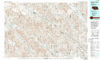
1985 Map of Broken Bow
USGS Topo · Published 1994About this map
Broken Bow serves as the regional hub in this mid-1980s landscape, where the Burlington Northern railroad cuts a diagonal path through the Sandhills transition zone. The map illustrates a complex network of valleys and tables, such as Redfern Table and West Table, which dictate the placement of agricultural settlements and roads. Irrigation is a vital component of the local economy, evidenced by the presence of Canal No 1 and Canal No 2 drawing from the Middle Loup River system. Significant recreational and utility features include the Pressey State Recreation Area and the Sherman Reservoir in the east. The terrain is deeply incised by numerous canyons and valleys, including Yellow Dog Canyon and Duchamin Valley, showing the erosion patterns typical of this part of Nebraska. Small railway towns like Berwyn, Ansley, and Mason City follow the tracks, marking the historic corridors of commerce and transit.
Find a feature on this map
70 named features on this map. Tap any name to fly to it.
Don’t see what you’re looking for? This feature index may not catch every label — zoom into the map to look around manually.
Map Details
Editions of this 1985 Broken Bow Map
2 editions found
Other maps of this area

1896 · Lexington
USGS Topo · 1:125,000

1896 · Kearney
USGS Topo · 1:125,000

1896 · Wood River
USGS Topo · 1:125,000

1899 · Lexington
USGS Topo · 1:125,000

1899 · Loup
USGS Topo · 1:125,000

1902 · Gothenburg
USGS Topo · 1:125,000

1948 · Linscott
USGS Topo · 1:62,500

1950 · Linscott
USGS Topo · 1:62,500

1951 · Broken Bow NE
USGS Topo · 1:24,000

1951 · Westerville
USGS Topo · 1:24,000