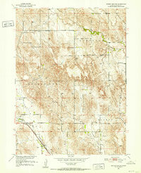
1951 Map of Broken Bow NE
USGS Topo · Published 1952About this map
French Tableland and the surrounding drainage basins define this portion of Custer County during the early 1950s. The landscape is marked by a network of rural school districts and small churches that served the agricultural community, including Snake Run School, Senate Valley School, and Bethel Church. The southern edge of the quadrangle is dominated by the transportation corridor following Muddy Creek, where the Chicago Burlington and Quincy railroad runs parallel to the waterway. This area also serves as a local hub for community activity, as evidenced by the Broken Bow Fairground and a nearby Radio Tower. The survey illustrates the transition from the upland plateaus down through the winding Dutchman Valley and Clear Creek systems, providing a detailed look at the rural infrastructure of central Nebraska before mid-century consolidation changed the local educational and social landscape.
Find a feature on this map
17 named features on this map. Tap any name to fly to it.
Don’t see what you’re looking for? This feature index may not catch every label — zoom into the map to look around manually.
Map Details
Editions of this 1951 Broken Bow NE Map
3 editions found
Other maps of this area

1951 · Broken Bow NE
USGS Topo · 1:24,000

1951 · Westerville
USGS Topo · 1:24,000

1951 · Broken Bow SW
USGS Topo · 1:24,000

1951 · Lillian
USGS Topo · 1:24,000

1951 · Ansley
USGS Topo · 1:24,000

1951 · Broken Bow
USGS Topo · 1:24,000

1951 · Broken Bow SE
USGS Topo · 1:24,000

1951 · Round Valley
USGS Topo · 1:24,000

1952 · Sargent SW
USGS Topo · 1:24,000

1955 · Broken Bow
USGS Topo · 1:250,000