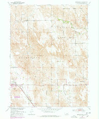
1951 Map of Broken Bow NE
USGS Topo · Published 1978About this map
Snake Run School and Senate Valley School anchor a landscape of small rural school districts across the rolling Nebraska hills northeast of Broken Bow. This mid-century survey reveals a highly localized social fabric, where one-room schoolhouses like Rose Valley School and Reed Valley School are spaced every few miles to serve the surrounding agricultural townships of Garfield, Broken Bow, and Berwyn. Along the southern corridor, the Burlington Northern railroad follows the course of Mud Creek, passing the Broken Bow Fairground and a mid-century Drive-in Theater. The map captures the distinctive topography of the region, from the high French Tableland in the northeast down into the drainage of Tappan Valley and Dutchman Valley. Local spiritual life is marked by the Broken View Church and Bethel Church, serving as landmarks in this sparsely populated Custer County landscape.
Find a feature on this map
19 named features on this map. Tap any name to fly to it.
Don’t see what you’re looking for? This feature index may not catch every label — zoom into the map to look around manually.
Map Details
Editions of this 1951 Broken Bow NE Map
3 editions found
Other maps of this area

1951 · Broken Bow NE
USGS Topo · 1:24,000

1951 · Westerville
USGS Topo · 1:24,000

1951 · Broken Bow SW
USGS Topo · 1:24,000

1951 · Lillian
USGS Topo · 1:24,000

1951 · Ansley
USGS Topo · 1:24,000

1951 · Broken Bow
USGS Topo · 1:24,000

1951 · Broken Bow SE
USGS Topo · 1:24,000

1951 · Round Valley
USGS Topo · 1:24,000

1952 · Sargent SW
USGS Topo · 1:24,000

1955 · Broken Bow
USGS Topo · 1:250,000