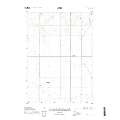
2017 Map of Broken Leg Dam
USGS Topo · Published 2017About this map
Broken Leg Dam sits in the southeastern corner of this landscape, anchoring a drainage network that defines the rural geography of Jackson County. The terrain is characterized by a series of distinct hydrologic zones including the West Cottonwood Creek Basin, East Cottonwood Creek Basin, and the larger Cottonwood Creek Basin to the south. These natural depressions and drainages, such as Settin Up Cr and Hay Cr, dictate the placement of local infrastructure and land divisions across the townships.
Find a feature on this map
14 named features on this map. Tap any name to fly to it.
Don’t see what you’re looking for? This feature index may not catch every label — zoom into the map to look around manually.
Map Details
Editions of this 2017 Broken Leg Dam Map
This is the sole edition of this map. No revisions or reprints were ever made.
Other maps of this area

1950 · Wanblee
USGS Topo · 1:24,000

1951 · Wanblee NW
USGS Topo · 1:24,000

1951 · Pass Creek NW
USGS Topo · 1:24,000

1951 · Wanblee NE
USGS Topo · 1:24,000

1955 · Martin
USGS Topo · 1:250,000

1958 · Martin
USGS Topo · 1:250,000

1980 · Kadoka
USGS Topo · 1:100,000

1981 · Long Valley
USGS Topo · 1:25,000

1981 · Broken Leg Dam
USGS Topo · 1:24,000
1981 · Short Bow Creek
USGS Topo · 1:25,000