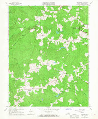
1966 Map of Brokenburg
USGS Topo · Published 1968About this map
Fredericksburg-Spotsylvania National Military Park dominates the northeast corner of this mid-century survey, preserving a landscape scarred by conflict. Earthworks like the Battle Trench are visible alongside the historic road network, including the legendary Brock Road and Catharpin Road. This rural stretch of Spotsylvania County is defined by its numerous small communities and corners that served as local hubs before modern expansion.
Find a feature on this map
39 named features on this map. Tap any name to fly to it.
Don’t see what you’re looking for? This feature index may not catch every label — zoom into the map to look around manually.
Map Details
Editions of this 1966 Brokenburg Map
3 editions found
Other maps of this area

1887 · Spottsylvania
USGS Topo · 1:125,000

1892 · Spottsylvania
USGS Topo · 1:125,000

1942 · Ladysmith
USGS Topo · 1:31,680

1942 · Partlow
USGS Topo · 1:31,680

1942 · Belmont
USGS Topo · 1:31,680

1942 · Contrary Creek
USGS Topo · 1:31,680

1942 · Spotsylania
USGS Topo · 1:31,680

1942 · Brokenburg
USGS Topo · 1:31,680

1943 · Chancellorsville
USGS Topo · 1:24,000

1943 · Salem Church
USGS Topo · 1:24,000