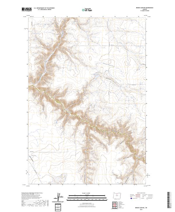
2023 Map of Bronx Canyon
USGS Topo · Published 2023About this map
Buck Hollow Creek carves a deep, winding path through the borderlands of Sherman and Wasco Counties, defining the complex drainage patterns of this high desert terrain. The landscape is characterized by a dense network of canyons and draws that feed into the primary creek system, including the namesake Bronx Canyon and the sharply cut Dead Dog Canyon in the southwest corner. These topographic features illustrate the erosional forces that have shaped this portion of the Columbia Plateau.
Find a feature on this map
30 named features on this map. Tap any name to fly to it.
Don’t see what you’re looking for? This feature index may not catch every label — zoom into the map to look around manually.
Map Details
Editions of this 2023 Bronx Canyon Map
This is the sole edition of this map. No revisions or reprints were ever made.
Other maps of this area

1953 · The Dalles
USGS Topo · 1:250,000

1956 · The Dalles
USGS Topo · 1:250,000

1957 · The Dalles
USGS Topo · 1:250,000

1962 · Sinamox
USGS Topo · 1:24,000

1962 · Grass Valley
USGS Topo · 1:24,000

1970 · Kent
USGS Topo · 1:24,000

1970 · Macken Canyon
USGS Topo · 1:24,000

1970 · Rosebush
USGS Topo · 1:24,000
1971 · Dead Dog Canyon
USGS Topo · 1:24,000
1971 · Bronx Canyon
USGS Topo · 1:24,000