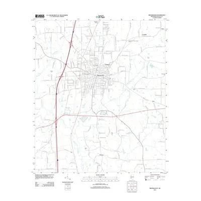
2012 Map of Brookhaven
USGS Topo · Published 2012About this map
Brookhaven serves as the central hub of Lincoln County, defined by its historic rail infrastructure at Mississippi Central Junction. This 2012 survey illustrates the city's modern layout as it surrounds the Illinois Central RR and branches out toward the residential area of Pearlhaven. The landscape is deeply carved by the river system of the Bogue Chitto, with its western, eastern, and main branches creating a complex drainage network that historically dictated the placement of settlements and transport routes.
Find a feature on this map
46 named features on this map. Tap any name to fly to it.
Don’t see what you’re looking for? This feature index may not catch every label — zoom into the map to look around manually.
Map Details
Editions of this 2012 Brookhaven Map
This is the sole edition of this map. No revisions or reprints were ever made.
Other maps of this area

1953 · Natchez
USGS Topo · 1:250,000

1956 · Natchez
USGS Topo · 1:250,000

1959 · Natchez
USGS Topo · 1:250,000

1972 · West Lincoln
USGS Topo · 1:24,000

1972 · Fair Oak Springs
USGS Topo · 1:24,000

1972 · Midway
USGS Topo · 1:24,000

1972 · Ruth
USGS Topo · 1:24,000

1972 · Bogue Chitto
USGS Topo · 1:24,000
1972 · Stronghope
USGS Topo · 1:24,000

1972 · Brookhaven
USGS Topo · 1:24,000