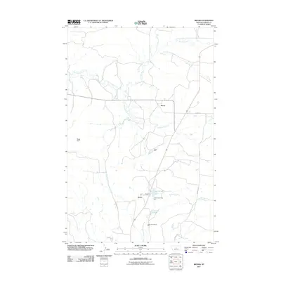
2011 Map of Brooks
USGS Topo · Published 2011About this map
Brooks and the nearby settlement of Baxter anchor this Fergus County landscape, where the prairie begins to break against the rising form of Rocky Butte. The 2011 survey reveals an environment defined by its water management and agricultural transport network, specifically the series of impoundments including Upper Carters Pond and Carters Pond along Burnette Creek. Local heritage is marked by Sunset Memorial Gardens, situated just west of the primary road corridor. The map details an intricate drainage system where Warm Spring Creek and Moccasin Creek wind through the terrain, supported by specialized infrastructure like the Lower Carter Pond Dam and Colver Dam. Historic travel patterns are preserved in the naming of rural routes such as the Old Denton Cutoff and Maiden Cutoff, providing a clear look at the regional connectivity between ranching hubs and smaller communities in the early 21st century.
Find a feature on this map
21 named features on this map. Tap any name to fly to it.
Don’t see what you’re looking for? This feature index may not catch every label — zoom into the map to look around manually.
Map Details
Editions of this 2011 Brooks Map
This is the sole edition of this map. No revisions or reprints were ever made.
Other maps of this area

1941 · Lewistown
USGS Topo · 1:62,500

1944 · Lewistown
USGS Topo · 1:62,500

1954 · Lewistown
USGS Topo · 1:250,000

1959 · Lewistown
USGS Topo · 1:250,000

1970 · Glengarry
USGS Topo · 1:24,000

1970 · Spring Creek Junction
USGS Topo · 1:24,000

1978 · Seventytwo Hills
USGS Topo · 1:24,000

1978 · Lewistown
USGS Topo · 1:100,000
1985 · Kendall
USGS Topo · 1:24,000

1985 · Hilger
USGS Topo · 1:24,000