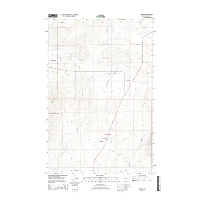
2014 Map of Brooks
USGS Topo · Published 2014About this map
Brooks and Baxter serve as the primary focal points of this Fergus County landscape, where the agricultural plains meet the foothills of the South Moccasin Mountains. The terrain is defined by a dense network of seasonal and perennial waterways, including Warm Spring Cr, Moccasin Cr, and Burnette Cr, which drain from the higher elevations of Rocky Butte toward the valley floors. Transportation in this era is anchored by Us-191 and MT-81, linking these rural communities and providing access to family-named landmarks like Carters Pond and Upper Carters Pond. Genealogists will find interest in Sunset Memorial Gardens, while the inclusion of various local tracks such as Denton Cutoff and Maiden Rd illustrates the established rural road system used by generations of Montana ranching and farming families.
Find a feature on this map
31 named features on this map. Tap any name to fly to it.
Don’t see what you’re looking for? This feature index may not catch every label — zoom into the map to look around manually.
Map Details
Editions of this 2014 Brooks Map
This is the sole edition of this map. No revisions or reprints were ever made.
Other maps of this area

1941 · Lewistown
USGS Topo · 1:62,500

1944 · Lewistown
USGS Topo · 1:62,500

1954 · Lewistown
USGS Topo · 1:250,000

1959 · Lewistown
USGS Topo · 1:250,000

1970 · Glengarry
USGS Topo · 1:24,000

1970 · Spring Creek Junction
USGS Topo · 1:24,000

1978 · Seventytwo Hills
USGS Topo · 1:24,000

1978 · Lewistown
USGS Topo · 1:100,000
1985 · Kendall
USGS Topo · 1:24,000

1985 · Hilger
USGS Topo · 1:24,000