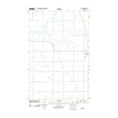
2010 Map of Brooks
USGS Topo · Published 2010About this map
Brooks serves as the central hub of this Red Lake County landscape, a community defined by its proximity to a dense network of meandering waterways. The Brooks Post Office and nearby religious sites, including Saint Joseph Cemetery and Presbyterian Cemetery, anchor the local history of this settlement. The terrain is dominated by the intricate hydrology of the Red River Valley, where the Clearwater River and Lost River snake across the northern sections, joined by the Hill River and Poplar River further south. This 2010 survey reflects a rural infrastructure built around these natural drainages, supplemented by man-made channels like County Ditch Number Seventeen and County Ditch Number Four. A grid of county highways, including County Hwy-120 and County Hwy-21, facilitates movement through the agricultural lands between Terrebonne Creek and Beau Gerlot Creek.
Find a feature on this map
29 named features on this map. Tap any name to fly to it.
Don’t see what you’re looking for? This feature index may not catch every label — zoom into the map to look around manually.
Map Details
Editions of this 2010 Brooks Map
This is the sole edition of this map. No revisions or reprints were ever made.
Other maps of this area

1918 · Terrebonne
USGS Topo · 1:62,500

1919 · Grit
USGS Topo · 1:62,500

1919 · Valley
USGS Topo · 1:62,500

1952 · Grand Forks
USGS Topo · 1:250,000

1954 · Bemidji
USGS Topo · 1:250,000

1956 · Grand Forks
USGS Topo · 1:250,000

1957 · Bemidji
USGS Topo · 1:250,000

1958 · Bemidji
USGS Topo · 1:250,000
1964 · Plummer NW
USGS Topo · 1:24,000

1964 · Terrebonne
USGS Topo · 1:24,000