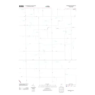
2013 Map of Brookston NW
USGS Topo · Published 2013About this map
Reynolds occupies the northeast corner of this White County landscape, serving as a primary point of human settlement in an area otherwise dominated by a complex network of agricultural water management. The terrain is defined by a grid-like system of ditches and natural creek beds that highlight the engineering required for farming in this part of Indiana. Significant waterways like Big Cr and Honey Cr are augmented by numerous man-made channels including Scipio Ditch, Fraser Ditch, and Bell Ditch. This 2013 survey illustrates how modern rural infrastructure follows early section lines, with roads like W Smithson Rd and W Shoop Rd cutting across a drainage system that includes Dorsey Ditch and Hoagland Ditch. The map provides a clear record of the precise hydrological footprint of the region at the start of the twenty-first century.
Find a feature on this map
37 named features on this map. Tap any name to fly to it.
Don’t see what you’re looking for? This feature index may not catch every label — zoom into the map to look around manually.
Map Details
Editions of this 2013 Brookston NW Map
This is the sole edition of this map. No revisions or reprints were ever made.
Other maps of this area

1953 · Danville
USGS Topo · 1:250,000

1955 · Danville
USGS Topo · 1:250,000

1956 · Danville
USGS Topo · 1:250,000

1962 · Brookston SW
USGS Topo · 1:24,000

1962 · Monticello South
USGS Topo · 1:24,000
1962 · Round Grove
USGS Topo · 1:24,000

1962 · Templeton NE
USGS Topo · 1:24,000

1962 · Brookston NW
USGS Topo · 1:24,000

1962 · Monon
USGS Topo · 1:24,000

1962 · Monticello North
USGS Topo · 1:24,000