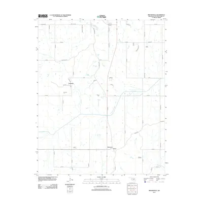
2012 Map of Brooksville
USGS Topo · Published 2012About this map
Brooksville and the surrounding Pottawatomie County countryside are defined by a grid of rural roads and the meandering path of the Little River. In the early 21st century, this area maintained its quiet character, with small settlements like Chisney and Macomb-Y serving as local landmarks. The landscape is dotted with several family and community burial grounds, including Forest Hill Cem and Ruggles Cem, which offer significant value for genealogical research in the region. Water features such as Dance Cr and the E T Cope Reservoir break the rectilinear patterns of the section lines. The presence of Old Santa Fe Lake Rd and Old Highway 18 suggests the evolution of transportation routes through this part of Oklahoma, connecting older homesteads and farms to the larger regional network.
Find a feature on this map
53 named features on this map. Tap any name to fly to it.
Don’t see what you’re looking for? This feature index may not catch every label — zoom into the map to look around manually.
Map Details
Editions of this 2012 Brooksville Map
This is the sole edition of this map. No revisions or reprints were ever made.
Other maps of this area

1896 · Seminole and Prague
USGS Topo · 1:125,000

1898 · Purcell
USGS Topo · 1:125,000

1907 · Maud
USGS Topo · 1:62,500

1908 · Maud
USGS Topo · 1:62,500

1909 · Shawnee
USGS Topo · 1:62,500

1910 · McComb
USGS Topo · 1:62,500

1930 · McLoud
USGS Topo · 1:62,500

1954 · Oklahoma City
USGS Topo · 1:250,000

1957 · Oklahoma City
USGS Topo · 1:250,000
1958 · Tribbey
USGS Topo · 1:24,000