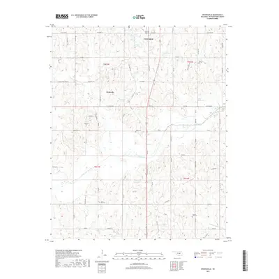
2018 Map of Brooksville
USGS Topo · Published 2018About this map
Brooksville and the southern outskirts of Tecumseh anchor this landscape in central Oklahoma, where the terrain is defined by the winding course of the Little River. The area shows a transition from small-town infrastructure to a rural interior marked by several water management projects, including North Deer Cr Lake and the E T Cope Reservoir. These reservoirs, alongside smaller bodies like 12503 Reservoir, illustrate the modern hydrologic management of the watershed. For those tracing local families, the map is particularly rich in burial sites, documenting Forest Hill Cem, Brooksville Cem, Ruggles Cem, and Prairie View Cem. The road network, including Hwy 18 and Sooner Rd, connects these remote points, while creek systems like Dance Cr and Sand Cr continue to shape the drainage patterns of the countryside south of the North Canadian river valley.
Find a feature on this map
72 named features on this map. Tap any name to fly to it.
Don’t see what you’re looking for? This feature index may not catch every label — zoom into the map to look around manually.
Map Details
Editions of this 2018 Brooksville Map
This is the sole edition of this map. No revisions or reprints were ever made.
Other maps of this area

1896 · Seminole and Prague
USGS Topo · 1:125,000

1898 · Purcell
USGS Topo · 1:125,000

1907 · Maud
USGS Topo · 1:62,500

1908 · Maud
USGS Topo · 1:62,500

1909 · Shawnee
USGS Topo · 1:62,500

1910 · McComb
USGS Topo · 1:62,500

1930 · McLoud
USGS Topo · 1:62,500

1954 · Oklahoma City
USGS Topo · 1:250,000

1957 · Oklahoma City
USGS Topo · 1:250,000
1958 · Tribbey
USGS Topo · 1:24,000