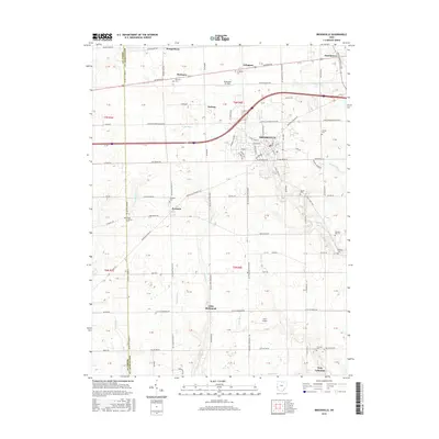
2016 Map of Brookville
USGS Topo · Published 2016About this map
The agrarian landscape of Montgomery and Preble counties is defined by a rigorous township and range grid, where historic crossroad settlements like Pyrmont and Dodson anchor the surrounding farmlands. The central hub of Brookville shows a concentrated residential pattern along Ankara Ave and Hay Ave, while the surrounding terrain is drained by a network of waterways including Wolf Creek and Toms Run.
Find a feature on this map
101 named features on this map. Tap any name to fly to it.
Don’t see what you’re looking for? This feature index may not catch every label — zoom into the map to look around manually.
Map Details
Editions of this 2016 Brookville Map
This is the sole edition of this map. No revisions or reprints were ever made.
Other maps of this area

1905 · Brookville
USGS Topo · 1:62,500

1908 · Miamisburg
USGS Topo · 1:62,500

1911 · Oxford
USGS Topo · 1:62,500

1953 · Cincinnati
USGS Topo · 1:250,000

1955 · Miamisburg
USGS Topo · 1:24,000

1955 · West Milton
USGS Topo · 1:24,000
1955 · Trotwood
USGS Topo · 1:24,000

1957 · Cincinnati
USGS Topo · 1:250,000

1960 · Farmersville
USGS Topo · 1:24,000

1961 · Laura
USGS Topo · 1:24,000