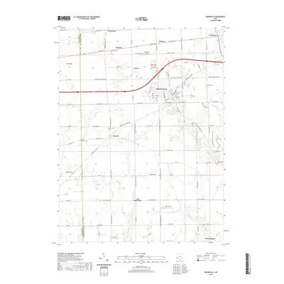
2019 Map of Brookville
USGS Topo · Published 2019About this map
The town of Brookville serves as the central hub of this southwestern Ohio landscape, where the agricultural legacy of the Miami Valley meets modern transportation corridors. Settled along the banks of Wolf Creek, the area is punctuated by long-established communities including Pyrmont, Arlington, and New Lebanon. The density of family and community burial grounds, such as Bachman Cem and Eversole Cem, highlights the deep generational roots found throughout the townships. Small-scale aviation history is visible at the Brookville Air-Park and Stone Airport, which break the pattern of traditional farmsteads. The drainage network, defined by Toms Run, Wysong Run, and Bear Creek, illustrates the natural irrigation that sustained these rural settlements long before the modern expansion of National Road and the surrounding highway system.
Find a feature on this map
68 named features on this map. Tap any name to fly to it.
Don’t see what you’re looking for? This feature index may not catch every label — zoom into the map to look around manually.
Map Details
Editions of this 2019 Brookville Map
This is the sole edition of this map. No revisions or reprints were ever made.
Other maps of this area

1905 · Brookville
USGS Topo · 1:62,500

1908 · Miamisburg
USGS Topo · 1:62,500

1911 · Oxford
USGS Topo · 1:62,500

1953 · Cincinnati
USGS Topo · 1:250,000

1955 · Miamisburg
USGS Topo · 1:24,000

1955 · West Milton
USGS Topo · 1:24,000
1955 · Trotwood
USGS Topo · 1:24,000

1957 · Cincinnati
USGS Topo · 1:250,000

1960 · Farmersville
USGS Topo · 1:24,000

1961 · Laura
USGS Topo · 1:24,000