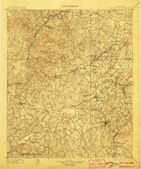
1899 Map of Brookwood
USGS Topo · Published 1906About this map
The Warrior River and its many winding tributaries like Davis Creek and Blue Creek carve through the central Alabama coal and iron belt on this 1895 survey. The landscape reflects an era of industrial growth where railroads such as the Louisville & Nashville RR and Birmingham Mineral RR began connecting mineral-rich sites like Brookwood, Tannehill, and Goethite. These settlements developed alongside a network of older crossings, including Patton Ferry and Locke Ford, that served travelers before the expansion of rail infrastructure.
Find a feature on this map
132 named features on this map. Tap any name to fly to it.
Don’t see what you’re looking for? This feature index may not catch every label — zoom into the map to look around manually.
Map Details
Editions of this 1899 Brookwood Map
4 editions found
Other maps of this area

1889 · Birmingham
USGS Topo · 1:125,000

1890 · Bessemer
USGS Topo · 1:125,000

1891 · Clanton
USGS Topo · 1:125,000

1892 · Birmingham
USGS Topo · 1:125,000

1892 · Bessemer
USGS Topo · 1:125,000

1893 · Jasper
USGS Topo · 1:125,000

1895 · Birmingham
USGS Topo · 1:125,000

1899 · Brookwood
USGS Topo · 1:125,000

1904 · Birmingham Coal District
USGS Topo · 1:62,500

1905 · Bessemer Iron District
USGS Topo · 1:62,500