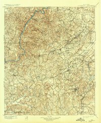
1899 Map of Brookwood
USGS Topo · Published 1932About this map
The Warrior River and Cahaba River carve through this central Alabama landscape, framing a late-19th-century industrial and agricultural corridor. At the heart of the map, Brookwood and Yolande stand as key settlements amidst a rugged interior defined by ridges like Iron Ore Mtn and Shades Mtn. The transport network is particularly dense in the northeast, where the Birmingham Southern RR and Louisville and Nashville RR intersect near coal and iron mining outposts like Belle Sumter and Adger.
Find a feature on this map
116 named features on this map. Tap any name to fly to it.
Don’t see what you’re looking for? This feature index may not catch every label — zoom into the map to look around manually.
Map Details
Editions of this 1899 Brookwood Map
4 editions found
Other maps of this area

1889 · Birmingham
USGS Topo · 1:125,000

1890 · Bessemer
USGS Topo · 1:125,000

1891 · Clanton
USGS Topo · 1:125,000

1892 · Birmingham
USGS Topo · 1:125,000

1892 · Bessemer
USGS Topo · 1:125,000

1893 · Jasper
USGS Topo · 1:125,000

1895 · Birmingham
USGS Topo · 1:125,000

1899 · Brookwood
USGS Topo · 1:125,000

1904 · Birmingham Coal District
USGS Topo · 1:62,500

1905 · Bessemer Iron District
USGS Topo · 1:62,500