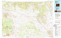
1983 Map of Brothers
USGS Topo · Published 1994About this map
High desert landscapes and volcanic geology dominate this central Oregon survey, which covers the transition from the high lava plains into the southern reaches of the Ochoco National Forest. Small ranching outposts like Millican, Brothers, and Imperial are positioned along the primary east-west corridor, revealing the sparse settlement patterns of the early 1980s. The terrain is defined by dramatic rises such as Bear Creek Buttes and Pine Mountain, while the southern portion of the map is marked by the distinct basaltic fields of Lava and the rugged expanse of The Devils Garden.
Find a feature on this map
39 named features on this map. Tap any name to fly to it.
Don’t see what you’re looking for? This feature index may not catch every label — zoom into the map to look around manually.
Map Details
Editions of this 1983 Brothers Map
2 editions found
Other maps of this area

1926 · Bend
USGS Topo · 1:125,000

1929 · Bend
USGS Topo · 1:125,000

1931 · Newberry Crater
USGS Topo · 1:125,000

1932 · Dayville
USGS Topo · 1:125,000

1935 · Newberry Crater
USGS Topo · 1:125,000

1936 · Dayville
USGS Topo · 1:125,000

1946 · Eagle Rock
USGS Topo · 1:62,500

1948 · Eagle Rock
USGS Topo · 1:62,500

1951 · Post
USGS Topo · 1:62,500

1955 · Crescent
USGS Topo · 1:250,000