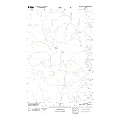
2011 Map of Brown Creek Ridge
USGS Topo · Published 2011About this map
Brown Creek Ridge dominates this Idaho landscape, where a complex network of drainage systems defines the topography. In this 2011 survey, the convergence of high-country waters like Lolo Creek and Musselshell Creek illustrates the intricate watershed geography of Idaho County. Human presence is largely defined by forestry and recreational access, as seen with the Lolo Creek Campground and a series of technical access ways including Natl Forest Develop Road 5111. The map reveals the interplay between the steep terrain of Deer Gulch and the winding paths of smaller tributaries such as Pete and Charlie Creek and Blonde Creek. This modern survey records the persistent primitive road networks, like Lacy Meadows Rd and Mud Creek Rd, which provide essential passage through the heavy timber and high ridges.
Find a feature on this map
27 named features on this map. Tap any name to fly to it.
Don’t see what you’re looking for? This feature index may not catch every label — zoom into the map to look around manually.
Map Details
Editions of this 2011 Brown Creek Ridge Map
This is the sole edition of this map. No revisions or reprints were ever made.
Other maps of this area

1924 · Weippe
USGS Topo · 1:125,000

1956 · Hamilton
USGS Topo · 1:250,000

1959 · Hamilton
USGS Topo · 1:250,000

1960 · Hamilton
USGS Topo · 1:250,000

1964 · Hamilton
USGS Topo · 1:250,000

1966 · Kooskia
USGS Topo · 1:24,000

1966 · Pierce
USGS Topo · 1:24,000
1966 · Glenwood
USGS Topo · 1:24,000
1966 · Hemlock Butte
USGS Topo · 1:24,000
1966 · Brown Creek Ridge
USGS Topo · 1:24,000