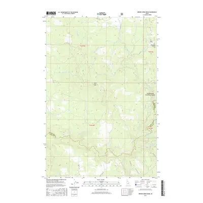
2017 Map of Brown Creek Ridge
USGS Topo · Published 2017About this map
Brown Creek Ridge dominates the central landscape of this Idaho County survey, marking the transition between the watershed of Lolo Creek and the intricate drainage networks to the north. The area is heavily defined by the boundaries of the Clearwater National Forest, where high-elevation landmarks like Musselshell Meadows and Deer Gulch indicate the remote and managed nature of the terrain. A complex system of forest and county roads, including Mussell Shell Rd, Lolo Creek Rd, and the descriptively named School House Rd, provides access through the timbered hills. The hydrography is particularly dense, with numerous named tributaries such as Jim Brown Cr, Mosquito Cr, and Pete and Charlie Cr carving through the valleys. This 2017 edition reflects the modern management of these public lands while preserving the traditional place names of the northern Idaho wilderness.
Find a feature on this map
39 named features on this map. Tap any name to fly to it.
Don’t see what you’re looking for? This feature index may not catch every label — zoom into the map to look around manually.
Map Details
Editions of this 2017 Brown Creek Ridge Map
This is the sole edition of this map. No revisions or reprints were ever made.
Other maps of this area

1924 · Weippe
USGS Topo · 1:125,000

1956 · Hamilton
USGS Topo · 1:250,000

1959 · Hamilton
USGS Topo · 1:250,000

1960 · Hamilton
USGS Topo · 1:250,000

1964 · Hamilton
USGS Topo · 1:250,000

1966 · Kooskia
USGS Topo · 1:24,000

1966 · Pierce
USGS Topo · 1:24,000
1966 · Glenwood
USGS Topo · 1:24,000
1966 · Hemlock Butte
USGS Topo · 1:24,000
1966 · Brown Creek Ridge
USGS Topo · 1:24,000