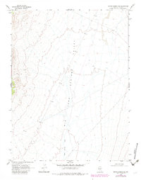
1968 Map of Brown Summit SW
USGS Topo · Published 1982About this map
Big Sand Springs Valley defines the topography of this high-desert region in Nye County, as documented by the U.S. Geological Survey through aerial photography and field checks. The expansive valley floor is characterized by the prominent drainage of Sand Springs Wash, which snakes northward through the alluvial terrain. The map reflects a landscape of stark geological features and vast open spaces, captured during a 1967 survey and later updated with photorevisions in the early 1980s. This specific survey provides a detailed look at the water-carved channels and elevation gradients of this corner of Nevada before later modern developments, serving as a primary source for understanding the hydrologic patterns and natural landforms of the Great Basin.
Find a feature on this map
2 named features on this map. Tap any name to fly to it.
Don’t see what you’re looking for? This feature index may not catch every label — zoom into the map to look around manually.
Map Details
Editions of this 1968 Brown Summit SW Map
2 editions found
Other maps of this area

1956 · Lund
USGS Topo · 1:250,000

1956 · Tonopah
USGS Topo · 1:250,000

1959 · Tonopah
USGS Topo · 1:250,000

1960 · Lund
USGS Topo · 1:250,000

1962 · Tonopah
USGS Topo · 1:250,000

1967 · Moores Station
USGS Topo · 1:62,500

1967 · Chaos Creek
USGS Topo · 1:24,000

1968 · Portuguese Mtn
USGS Topo · 1:62,500

1968 · Brown Summit
USGS Topo · 1:24,000
1968 · Brown Summit NW
USGS Topo · 1:24,000