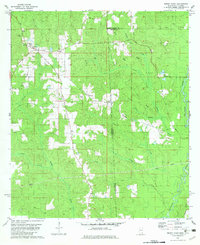
1982 Map of Brown Town
USGS Topo · Published 1982About this map
Mt Pisgah Ch and the surrounding rural community of Pisgah anchor the western reaches of this landscape, where the border between Alabama and Mississippi crosses through timbered drainage basins. The area is defined by its complex waterway network, including Brushy Creek and Lott Creek, which feed toward the Esca Tawpa River on the eastern edge. Settlement patterns are sparse, with clusters like Brown Town and Davis appearing along the local roads. Evidence of small-scale industry and infrastructure is visible through the presence of a Sandpit and a Lookout Tower, alongside modern pipelines cutting across the terrain. For genealogists, the map preserves the locations of rural landmarks such as Meboba Ch and the Maples Cem, providing a precise record of these community centers in the early 1980s before significant changes in land use.
Find a feature on this map
30 named features on this map. Tap any name to fly to it.
Don’t see what you’re looking for? This feature index may not catch every label — zoom into the map to look around manually.
Map Details
Editions of this 1982 Brown Town Map
3 editions found
Other maps of this area

1941 · Lucedale
USGS Topo · 1:62,500

1942 · Deer Park
USGS Topo · 1:62,500

1942 · Wilmer
USGS Topo · 1:62,500

1943 · Lucedale
USGS Topo · 1:62,500

1943 · Deer Park
USGS Topo · 1:62,500

1944 · Wilmer
USGS Topo · 1:62,500

1953 · Hattiesburg
USGS Topo · 1:250,000

1953 · Mobile
USGS Topo · 1:250,000

1957 · Mobile
USGS Topo · 1:250,000

1958 · Hattiesburg
USGS Topo · 1:250,000