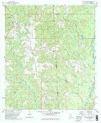
1982 Map of Brown Town
USGS Topo · Published 1984About this map
Brown Town and Pisgah serve as local hubs in this 1982 survey of the rural borderlands where Mississippi meets Alabama. The landscape is defined by the winding course of the Escatawpa River and a series of prominent high points like Beverly Ridge and Denmark Ridge. A network of small rural outposts is documented here, including the Davis settlement and several community landmarks such as Mt Pisgah Ch and Mabry Ch.
Find a feature on this map
32 named features on this map. Tap any name to fly to it.
Don’t see what you’re looking for? This feature index may not catch every label — zoom into the map to look around manually.
Map Details
Editions of this 1982 Brown Town Map
3 editions found
Other maps of this area

1941 · Lucedale
USGS Topo · 1:62,500

1942 · Deer Park
USGS Topo · 1:62,500

1942 · Wilmer
USGS Topo · 1:62,500

1943 · Lucedale
USGS Topo · 1:62,500

1943 · Deer Park
USGS Topo · 1:62,500

1944 · Wilmer
USGS Topo · 1:62,500

1953 · Hattiesburg
USGS Topo · 1:250,000

1953 · Mobile
USGS Topo · 1:250,000

1957 · Mobile
USGS Topo · 1:250,000

1958 · Hattiesburg
USGS Topo · 1:250,000