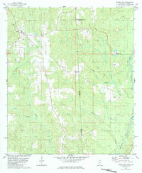
1982 Map of Brown Town
USGS Topo · Published 1984About this map
The Alabama Mississippi state line bisects this 1982 survey, dividing a landscape of dense creek networks and small timber-country settlements. Brown Town sits near the center of the sheet, surrounded by a complex drainage system where Nobodies Creek and Lott Branch flow toward the Escatawpa River. The map provides significant detail for genealogists, recording the Maples Cem and rural congregations such as Mt Pisgah Ch and Mohoba Ch. Industrial and utility infrastructure is evident through the presence of a Sandpit near Pisgah and a network of Pipelines crossing the state boundary. This document captures the transition from high ridge topography down to the river bottoms during the early 1980s, documenting exactly where local roads like Blankenship Road and Beverly Road connected these isolated communities.
Find a feature on this map
29 named features on this map. Tap any name to fly to it.
Don’t see what you’re looking for? This feature index may not catch every label — zoom into the map to look around manually.
Map Details
Editions of this 1982 Brown Town Map
3 editions found
Other maps of this area

1941 · Lucedale
USGS Topo · 1:62,500

1942 · Deer Park
USGS Topo · 1:62,500

1942 · Wilmer
USGS Topo · 1:62,500

1943 · Lucedale
USGS Topo · 1:62,500

1943 · Deer Park
USGS Topo · 1:62,500

1944 · Wilmer
USGS Topo · 1:62,500

1953 · Hattiesburg
USGS Topo · 1:250,000

1953 · Mobile
USGS Topo · 1:250,000

1957 · Mobile
USGS Topo · 1:250,000

1958 · Hattiesburg
USGS Topo · 1:250,000