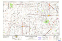
1954 Map of Brownfield
USGS Topo · Published 1975About this map
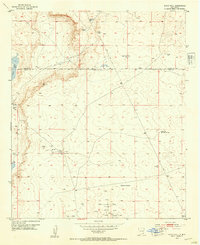
Muleshoe NWR and the sprawling Oil and Gas Field define this high plains landscape across the Texas-New Mexico border. The mid-century development of the Permian Basin's northern reaches is evident in the dense network of roads and pipelines connecting towns like Sundown, Levelland, and the regional hub of Brownfield. Outside of the industrialized energy zones, the terrain is characterized by alkaline basins and intermittent water bodies such as Bull Lake, Yellow Lake, and Mound Lake. The importance of water and transport in this semi-arid region is highlighted by the course of Yellow House Draw and the Atchison Topeka and Santa Fe RR corridors. Along the western edge, the distinct transition from the plains to the desert is marked by the Mescalero Ridge and the sandy expanses of Mescalero Sands. Small communities like Friendship, Pep, and Tokio serve as remote anchors in a landscape dominated by ranching and resource extraction.
Find a feature on this map
97 named features on this map. Tap any name to fly to it.
Don’t see what you’re looking for? This feature index may not catch every label — zoom into the map to look around manually.
Map Details
Editions of this 1954 Brownfield Map
2 editions found

Other maps of this area
1949 · Sardine Mountain
USGS Topo · 1:24,000

1949 · Malstrom Ranch
USGS Topo · 1:24,000
1951 · King Camp
USGS Topo · 1:24,000
1952 · Connor Well
USGS Topo · 1:24,000
1953 · Basin Well
USGS Topo · 1:24,000

1954 · Lubbock
USGS Topo · 1:250,000

1954 · Carlsbad
USGS Topo · 1:250,000

1954 · Hobbs
USGS Topo · 1:250,000

1954 · Fort Sumner
USGS Topo · 1:250,000

1954 · Big Spring
USGS Topo · 1:250,000