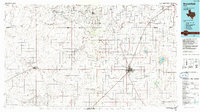
1985 Map of Brownfield
USGS Topo · Published 1992About this map
Brownfield serves as the primary hub of this High Plains landscape, where the grid of the Texas South Plains is defined by a dense network of energy extraction and agricultural transit. The map documents an intensive mid-1980s industrial footprint, dominated by the Prentice Oil and Gas Field, Brahaney Oil Field, and the sprawling Levelland and Slaughter Oil and Gas Field to the north. These fields are etched across the terrain alongside ephemeral water features like Mound Lake and Rich Lake.
Find a feature on this map
51 named features on this map. Tap any name to fly to it.
Don’t see what you’re looking for? This feature index may not catch every label — zoom into the map to look around manually.
Map Details
Editions of this 1985 Brownfield Map
2 editions found
Other maps of this area

1954 · Lubbock
USGS Topo · 1:250,000

1954 · Hobbs
USGS Topo · 1:250,000

1954 · Big Spring
USGS Topo · 1:250,000

1954 · Brownfield
USGS Topo · 1:250,000

1957 · New Home
USGS Topo · 1:62,500

1957 · Lubbock West
USGS Topo · 1:24,000

1957 · Lubbock
USGS Topo · 1:62,500

1957 · Meadow
USGS Topo · 1:62,500

1957 · Wolfforth
USGS Topo · 1:62,500

1958 · Brownfield
USGS Topo · 1:250,000