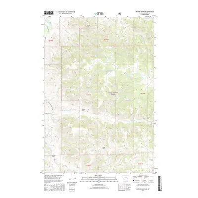
2017 Map of Browns Mountain
USGS Topo · Published 2017About this map
Custer National Forest lands dominate this part of Rosebud County, where the terrain is defined by a dense network of gulches and draws. The high point of Browns Mtn rises above the drainage of Black Eagle Cr, while further south, the landscape is carved by Roberts Gulch and Wild Hog Coulee. This 2017 survey documents an extensive water management system essential for this environment, featuring named sources like Black Eagle Spring Number One and Black Eagle Spring Number Two, alongside several catchment points including Roberts Gulch Reservoir and Timber Cr Reservoir. The road network is largely dictated by the topography, with Ashland-Birney Rd and Tongue River Rd skirting the western edges near the Tongue River, providing access to remote ranching land like that accessed via Bones Ranch Rd.
Find a feature on this map
42 named features on this map. Tap any name to fly to it.
Don’t see what you’re looking for? This feature index may not catch every label — zoom into the map to look around manually.
Map Details
Editions of this 2017 Browns Mountain Map
This is the sole edition of this map. No revisions or reprints were ever made.
Other maps of this area

1954 · Hardin
USGS Topo · 1:250,000

1957 · Hardin
USGS Topo · 1:250,000

1958 · Hardin
USGS Topo · 1:250,000

1966 · Browns Mountain
USGS Topo · 1:24,000

1966 · Birney Day School
USGS Topo · 1:24,000

1966 · Poker Jim Butte
USGS Topo · 1:24,000
1966 · Green Creek
USGS Topo · 1:24,000

1967 · Clubfoot Creek
USGS Topo · 1:24,000

1967 · Birney
USGS Topo · 1:24,000

1967 · Lacey Gulch
USGS Topo · 1:24,000