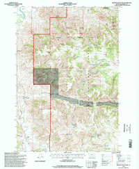
1995 Map of Browns Mountain
USGS Topo · Published 1998About this map
Custer National Forest dominates this section of Rosebud County, characterized by a complex drainage system feeding the north-flowing Tongue River. The landscape is a mix of public and private land, marked by the presence of working cattle operations such as Bones Ranch and Gilliland Ranch. These ranches are situated among a network of steep draws and gulches, including Hockley Gulch and McGhee Gulch, which rely on scattered water sources like Roberts Spring and Wild Hog Spring.
Find a feature on this map
46 named features on this map. Tap any name to fly to it.
Don’t see what you’re looking for? This feature index may not catch every label — zoom into the map to look around manually.
Map Details
Editions of this 1995 Browns Mountain Map
This is the sole edition of this map. No revisions or reprints were ever made.
Other maps of this area

1954 · Hardin
USGS Topo · 1:250,000

1957 · Hardin
USGS Topo · 1:250,000

1958 · Hardin
USGS Topo · 1:250,000

1966 · Browns Mountain
USGS Topo · 1:24,000

1966 · Birney Day School
USGS Topo · 1:24,000

1966 · Poker Jim Butte
USGS Topo · 1:24,000
1966 · Green Creek
USGS Topo · 1:24,000

1967 · Clubfoot Creek
USGS Topo · 1:24,000

1967 · Birney
USGS Topo · 1:24,000

1967 · Lacey Gulch
USGS Topo · 1:24,000