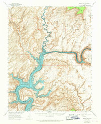
1952 Map of Browns Rim
USGS Topo · Published 1968About this map
The Colorado River carves through the heart of this canyonlands landscape, where the rising waters of Lake Powell meet the confluence of the Dirty Devil River. This 1952 field survey, published in cooperation with the Atomic Energy Commission, documents the terrain just as the uranium boom was transforming the region. Early mining activity is evident at the Happy Jack Mine and various other unnamed Mines scattered near White Canyon and Copper Point.
Find a feature on this map
43 named features on this map. Tap any name to fly to it.
Don’t see what you’re looking for? This feature index may not catch every label — zoom into the map to look around manually.
Map Details
Editions of this 1952 Browns Rim Map
3 editions found

Other maps of this area

1885 · San Rafael
USGS Topo · 1:250,000

1886 · Henry Mountains
USGS Topo · 1:250,000

1892 · Henry Mountains
USGS Topo · 1:250,000

1952 · Mouth of Dark Canyon
USGS Topo · 1:62,500

1952 · Orange Cliffs 3 SW
USGS Topo · 1:24,000

1952 · Mancos Mesa
USGS Topo · 1:62,500

1952 · Mt Pennell 1 NE
USGS Topo · 1:24,000

1952 · Natural Bridges
USGS Topo · 1:62,500

1952 · Mt Hillers
USGS Topo · 1:62,500

1952 · Mt Pennell 1 SE
USGS Topo · 1:24,000