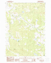
1988 Map of Brownsboro
USGS Topo · Published 1988About this map
Brownsboro sits at the junction of several drainage systems in Jackson County, where water management infrastructure defines the human imprint on the landscape. This late-twentieth-century survey reveals a complex network of irrigation and storage, including the Yankee Creek Reservoir, Lake Creek Reservoir, and the Yankee Creek Siphon. Small-scale local landmarks like the Schoolhouse and Cem cemetery near the main settlement provide essential coordinates for genealogical research. The terrain is marked by significant elevation changes, from the heights of Woodrat Knob to the Bradshaw Drop, while the economy is reflected in scattered Quarry sites and a Landing Strip. The map detail follows the winding paths of Little Butte Creek and its many tributaries, such as Bitterlick Creek and Kanutchan Creek, illustrating how water rights and topographic features dictated the placement of roads and rural homesteads.
Find a feature on this map
36 named features on this map. Tap any name to fly to it.
Don’t see what you’re looking for? This feature index may not catch every label — zoom into the map to look around manually.
Map Details
Editions of this 1988 Brownsboro Map
This is the sole edition of this map. No revisions or reprints were ever made.
Other maps of this area

1891 · Ashland
USGS Topo · 1:250,000

1893 · Ashland
USGS Topo · 1:250,000

1897 · Ashland
USGS Topo · 1:250,000

1938 · Medford
USGS Topo · 1:125,000

1943 · Trail
USGS Topo · 1:62,500

1954 · Medford
USGS Topo · 1:62,500

1954 · Butte Falls
USGS Topo · 1:62,500

1954 · Lakecreek
USGS Topo · 1:62,500

1955 · Medford
USGS Topo · 1:250,000

1957 · Medford
USGS Topo · 1:250,000