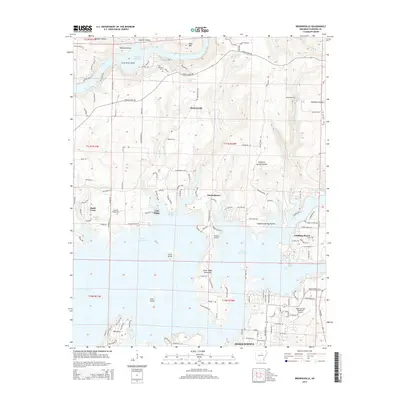
2014 Map of Brownsville
USGS Topo · Published 2014About this map
Greers Ferry Lake dominates this Cleburne County landscape, its sprawling, intricate shoreline creating numerous points and islands such as Scout Island and Goat Island. The map illustrates a contemporary recreational and residential layout, where settlements like Tannenbaum and Lake Ridge sit perched along the water's edge. To the south, the northern reaches of Heber Springs appear near the Heber Springs Municipal Airport, showing the town's expansion toward the lake.
Find a feature on this map
170 named features on this map. Tap any name to fly to it.
Don’t see what you’re looking for? This feature index may not catch every label — zoom into the map to look around manually.
Map Details
Editions of this 2014 Brownsville Map
This is the sole edition of this map. No revisions or reprints were ever made.
Other maps of this area

1890 · Batesville
USGS Topo · 1:125,000

1891 · Batesville
USGS Topo · 1:125,000

1892 · Mountain View
USGS Topo · 1:125,000

1894 · Mountain View
USGS Topo · 1:125,000

1953 · Memphis
USGS Topo · 1:250,000

1956 · Memphis
USGS Topo · 1:250,000

1956 · Russellville
USGS Topo · 1:250,000

1963 · Quitman
USGS Topo · 1:24,000

1963 · West Pangburn
USGS Topo · 1:24,000
1963 · Heber Springs
USGS Topo · 1:24,000