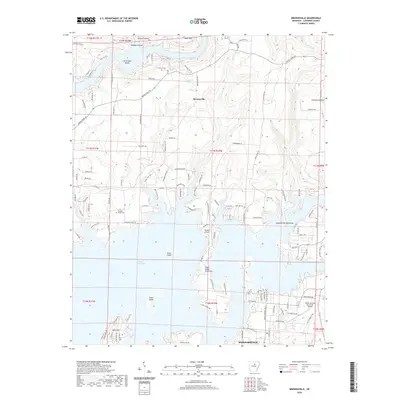
2020 Map of Brownsville
USGS Topo · Published 2020About this map
Greers Ferry Lake dominates the southern half of this landscape, its intricate shoreline creating numerous inlets and landforms like the Silver Ridge Peninsula and Scout Island. Along the northern shores and upper reaches of Budd Cr and Rocky Br, the terrain rises toward Bear Mtn, cut by deep hollows such as Wildcat Hollow and Simmons Hollow. The settlement pattern reflects both traditional rural life and modern lakeside development, with the established community of Brownsville and historic sites like Holland Cem and Pleasant Ridge Cem situated north of the newer resort area of Eden Isle. Regional connectivity is anchored by the Phalanx Airport near the lake's edge and the larger Heber Springs Municipal Airport to the southeast, while natural landmarks like Brownsville Spring and Dripping Spring speak to the area's hydrology before and after the reservoir's creation.
Find a feature on this map
131 named features on this map. Tap any name to fly to it.
Don’t see what you’re looking for? This feature index may not catch every label — zoom into the map to look around manually.
Map Details
Editions of this 2020 Brownsville Map
This is the sole edition of this map. No revisions or reprints were ever made.
Other maps of this area

1890 · Batesville
USGS Topo · 1:125,000

1891 · Batesville
USGS Topo · 1:125,000

1892 · Mountain View
USGS Topo · 1:125,000

1894 · Mountain View
USGS Topo · 1:125,000

1953 · Memphis
USGS Topo · 1:250,000

1956 · Memphis
USGS Topo · 1:250,000

1956 · Russellville
USGS Topo · 1:250,000

1963 · Quitman
USGS Topo · 1:24,000

1963 · West Pangburn
USGS Topo · 1:24,000
1963 · Heber Springs
USGS Topo · 1:24,000