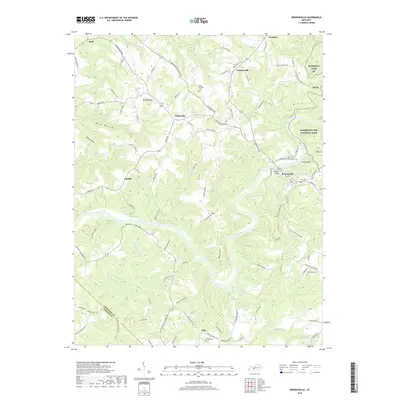
2019 Map of Brownsville
USGS Topo · Published 2019About this map
The Green River carves a deep, winding path through Edmonson County, serving as the central geographic feature of this landscape. Near the river's bend sits Brownsville, the county seat, where local landmarks like Lovers Leap and Potato Hill overlook the water. To the east, the boundary of Mammoth Cave National Park is clearly defined, showing how the protected karst landscape transitions into the surrounding rural communities of Lindseyville, Sweeden, and Windyville.
Find a feature on this map
104 named features on this map. Tap any name to fly to it.
Don’t see what you’re looking for? This feature index may not catch every label — zoom into the map to look around manually.
Map Details
Editions of this 2019 Brownsville Map
This is the sole edition of this map. No revisions or reprints were ever made.
Other maps of this area

1922 · Leitchfield
USGS Topo · 1:48,000

1922 · Brownsville
USGS Topo · 1:62,500

1922 · Mammoth Cave
USGS Topo · 1:62,500

1923 · Mammoth Cave
USGS Topo · 1:62,500

1923 · Brownsville
USGS Topo · 1:62,500

1925 · Cub Run
USGS Topo · 1:62,500

1925 · Leitchfield
USGS Topo · 1:62,500

1953 · Ready
USGS Topo · 1:24,000

1953 · Bee Spring
USGS Topo · 1:24,000

1954 · Evansville
USGS Topo · 1:250,000