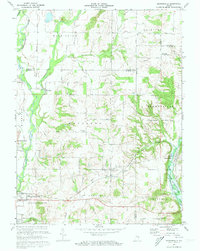
1972 Map of Brownsville
USGS Topo · Published 1973About this map
Whitewater River and its East Fork dominate this corner of eastern Indiana during the early 1970s, a period when the landscape was being reshaped by the development of Brookville Lake. This survey illustrates the controlled inundation areas along the river valley, marking a significant transition for the local topography. In the village of Brownsville, a Covered Bridge stands as a notable landmark near the river's edge, while the surrounding countryside is dotted with small settlements like Philomath, Waterloo, and Lyonsville. The cultural footprint of the area is well-preserved through numerous rural institutions, including the Philomath Ch, Township Sch, and Mt Pleasant Ch. Transport and trade are grounded in the Baltimore and Ohio railroad line running through the southern section, complemented by a network of named country roads such as Potter Shop Road and Philomath Road.
Find a feature on this map
48 named features on this map. Tap any name to fly to it.
Don’t see what you’re looking for? This feature index may not catch every label — zoom into the map to look around manually.
Map Details
Editions of this 1972 Brownsville Map
3 editions found
Other maps of this area

1915 · New Paris
USGS Topo · 1:48,000

1915 · College Corner
USGS Topo · 1:48,000

1918 · College Corner
USGS Topo · 1:62,500

1918 · New Paris
USGS Topo · 1:62,500

1948 · Fairfield
USGS Topo · 1:24,000

1953 · Cincinnati
USGS Topo · 1:250,000

1956 · Everton
USGS Topo · 1:24,000

1956 · Alpine
USGS Topo · 1:24,000

1956 · Brownsville
USGS Topo · 1:24,000

1956 · Connersville
USGS Topo · 1:24,000