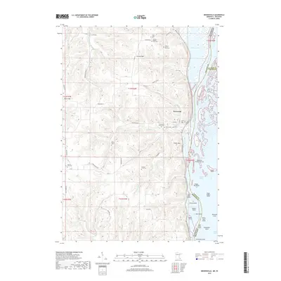
2019 Map of Brownsville
USGS Topo · Published 2019About this map
Brownsville sits at the base of the steep Mississippi River bluffs, where the valley walls meet the extensive wetlands and sloughs of the river bottoms. This landscape is defined by the sharp transition from the upland plateaus down to the water level, with Thompson Cr carving a narrow drainage path through the terrain. The settlement pattern follows the confined habitable land between the rising hills and the river’s edge, reflecting the historical importance of the river corridor for transportation and commerce in the region. The map detail shows the precise topography of these bluffs, which have long dictated the placement of roads and structures in this portion of the borderlands between Minnesota and Wisconsin.
Find a feature on this map
2 named features on this map. Tap any name to fly to it.
Don’t see what you’re looking for? This feature index may not catch every label — zoom into the map to look around manually.
Map Details
Editions of this 2019 Brownsville Map
This is the sole edition of this map. No revisions or reprints were ever made.
Other maps of this area

1926 · Stoddard
USGS Topo · 1:62,500

1927 · La Crosse
USGS Topo · 1:62,500

1930 · La Crescent
USGS Topo · 1:62,500

1930 · La Crosse
USGS Topo · 1:62,500

1956 · Brownsville
USGS Topo · 1:62,500

1956 · La Crescent
USGS Topo · 1:62,500

1958 · La Crosse
USGS Topo · 1:250,000

1961 · La Crosse
USGS Topo · 1:250,000
1963 · La Crosse
USGS Topo · 1:24,000
1963 · La Crosse
USGS Topo · 1:62,500