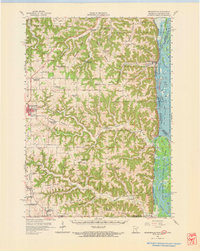
1956 Map of Brownsville
USGS Topo · Published 1968About this map
Mississippi River waters and the labyrinthine islands of the Upper Mississippi River Wildlife and Fish Refuge dominate the eastern edge of this mid-century survey. On the bluffs above the river, the village of Brownsville sits at the mouth of Wildcat Creek, while the interior landscape is defined by high ridges and deep hollows. The settlement pattern here is one of decentralized upland communities, evidenced by a dense network of country schools, many of which are noted as abandoned by the 1950s, such as Peacock Ridge Sch and Franklin Sch.
Find a feature on this map
87 named features on this map. Tap any name to fly to it.
Don’t see what you’re looking for? This feature index may not catch every label — zoom into the map to look around manually.
Map Details
Editions of this 1956 Brownsville Map
2 editions found
Other maps of this area

1903 · Waukon
USGS Topo · 1:125,000

1906 · Decorah
USGS Topo · 1:125,000

1926 · Stoddard
USGS Topo · 1:62,500

1927 · La Crosse
USGS Topo · 1:62,500

1929 · Ferryville
USGS Topo · 1:62,500

1930 · La Crescent
USGS Topo · 1:62,500

1930 · La Crosse
USGS Topo · 1:62,500

1932 · Ferryville
USGS Topo · 1:62,500

1956 · Brownsville
USGS Topo · 1:62,500

1956 · La Crescent
USGS Topo · 1:62,500