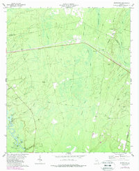
1978 Map of Browntown
USGS Topo · Published 1988About this map
Satilla River bottomlands and dense coastal wetlands dominate this 1970s landscape, where the confluence of rivers and swamps shaped local settlement patterns. Small communities like Browntown and Fendig are positioned along the higher ground, often connected by an Old Railroad Grade that speaks to the historical timber or transport industry of the area. The map reveals a distinct focus on family and local burial grounds, including the Little Memorial Cem, Mc Cool Cem, and Grayham Cem, which are often located near small houses of worship like Little Mem Ch.
Find a feature on this map
51 named features on this map. Tap any name to fly to it.
Don’t see what you’re looking for? This feature index may not catch every label — zoom into the map to look around manually.
Map Details
Editions of this 1978 Browntown Map
2 editions found
Other maps of this area

1917 · Nahunta
USGS Topo · 1:62,500

1918 · Hortense
USGS Topo · 1:62,500

1918 · Everett City
USGS Topo · 1:62,500

1918 · Nahunta
USGS Topo · 1:62,500

1918 · Bladen
USGS Topo · 1:62,500

1920 · Everett City
USGS Topo · 1:62,500

1939 · Bladen
USGS Topo · 1:62,500

1944 · Everett City
USGS Topo · 1:62,500

1944 · Hortense
USGS Topo · 1:62,500

1946 · Brunswick
USGS Topo · 1:250,000