
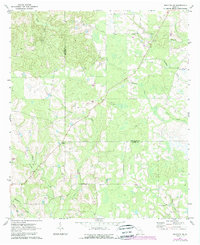
1971 Map of Broxton NE
USGS Topo · Published 1974About this map
Low-lying woodlands and winding creek basins define this 1971 survey of the Coffee and Jeff Davis County line. The landscape is marked by a network of rural churches and family-named landmarks that served as the social hubs for these agricultural communities. Moving south from Rocky Creek and the notable Rock Falls, the terrain is punctuated by small congregations like Byrd Ch and Carver Ch. The transition from forest to field is meticulously documented, with fine red dashed lines indicating the exact placement of fences and field boundaries visible during the 1969 aerial photography phase. These markers offer a rare glimpse into the specific land-use patterns of the era, from the banks of Moccasin Creek down to the southern settlements near West Green Ch and Marys Chapel.
Find a feature on this map
18 named features on this map. Tap any name to fly to it.
Don’t see what you’re looking for? This feature index may not catch every label — zoom into the map to look around manually.
Map Details
Editions of this 1971 Broxton NE Map
2 editions found
Other maps of this area

1953 · Waycross
USGS Topo · 1:250,000

1958 · Waycross
USGS Topo · 1:250,000

1971 · Douglas North
USGS Topo · 1:24,000

1971 · Nicholls
USGS Topo · 1:24,000

1971 · Roper
USGS Topo · 1:24,000

1971 · Snipesville
USGS Topo · 1:24,000

1971 · Denton
USGS Topo · 1:24,000

1972 · Broxton North
USGS Topo · 1:24,000

1972 · Jacksonville
USGS Topo · 1:24,000
1977 · Broxton South
USGS Topo · 1:24,000