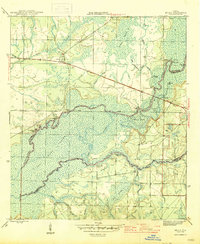
1945 Map of Bruce
USGS Topo · Published 1945This historical map portrays the area of Bruce in 1945, primarily covering Walton County as well as portions of Bay County and Washington County. Featuring a scale of 1:31680, this map provides a highly detailed snapshot of the terrain, roads, buildings, counties, and historical landmarks in the Bruce region at the time. Published in 1945, it is one of 3 known editions of this map due to revisions or reprints.
Find a feature on this map
36 named features on this map. Tap any name to fly to it.
Don’t see what you’re looking for? This feature index may not catch every label — zoom into the map to look around manually.
Map Details
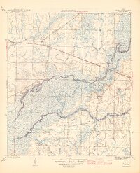
Editions of this 1945 Bruce Map
3 editions found
Historical Maps of Miller Bend Through Time
38 maps found

1935 De Funiak Springs
Walton County, FL

1935 Villa Tasso
Walton County, FL

1936 Point Washington
Walton County, FL

1938 De Funiak Springs
Walton County, FL

1938 Villa Tasso
Walton County, FL

1939 Point Washington
Walton County, FL

1944 Bruce
Walton County, FL

1945 Bruce
Walton County, FL

1948 Ponce De Leon
Walton County, FL

1949 Glendale
Walton County, FL

1949 Redbay
Walton County, FL

1950 Ponce De Leon
Walton County, FL

1950 Redbay
Walton County, FL

1951 Glendale
Walton County, FL

1956 Villa Tasso
Walton County, FL

1970 Bunker
Walton County, FL

1970 Choctaw Beach
Walton County, FL

1970 Grayton Beach
Walton County, FL

1970 Niceville SE
Walton County, FL

1970 Point Washington
Walton County, FL

1970 Portland
Walton County, FL

1970 Rock Hill
Walton County, FL

1973 Darlington
Walton County, FL

1973 De Funiak Springs East
Walton County, FL

1973 De Funiak Springs West
Walton County, FL

1973 Gaskin
Walton County, FL

1973 Glendale
Walton County, FL

1973 Liberty
Walton County, FL

1973 Mossy Head
Walton County, FL

1973 New Harmony
Walton County, FL

1974 Point Washington
Walton County, FL

1982 Bruce
Walton County, FL

1982 Ponce De Leon
Walton County, FL

1982 Redbay
Walton County, FL

1987 Darlington
Walton County, FL

1994 Choctaw Beach
Walton County, FL

1994 Ponce De Leon
Walton County, FL

1996 Point Washington
Walton County, FL